Documenting the City – Along the Geographical Paths of the Island of Nantes Planned by Urban Renewal
Park Seung-man
Department of Fine Arts
Where is Nantes urban project, globally known as a successful model of urban renewal, at this point? I first subdivided the areas under the urban project into the standards I had set – green spaces, developed and undeveloped regions, old towns, etc. – and explored them to witness how urban renewal had affected the urban environment and the locals. Although it was a short time, I tried documenting the city in the meantime.
The entire island was going through many changes under the Nantes project. Nantes unfolds before us in a bizarre landscape, making mechanical noises while transforming throughout time under the big urban regeneration plan. To this day, the change is still ongoing.
I. Objective
This research aims to introspect the current status and reality of urban renewal by documenting areas on the Island of Nantes affected by the urban renewal.
II. Extent of the Research
This research records changes in the regions on the Island of Nantes that were affected by urban renewal. It also includes the interview of the locals.
III. Research Methods
I subdivided the areas under the urban project based on my standards and conducted photo shooting and interviews.
IV. Results
Through this research, I had a chance to experience and document changing Nantes under urban renewal.
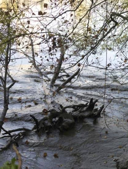
For the first thing, I needed to contact the citizens of Nantes for this project. I wanted to experience the city and witness how urban renewal influenced the lives of citizens over time. I first subdivided the areas for my investigation into four districts: (1) green spaces (e. g. swamps), the eastern part of the island, (2) some regions with urban development ongoing or completed, (3) other areas planned for future urban development, (4) areas outside of the Island of Nantes (e. g. old town, residential area, etc.) Among the four districts, the first places I visited were the Nantes Saint-Nazaire school of fine art and the National Superior School of Architecture of Nantes located in the western part of the island. In many parts of this area, the development plans were already either progressed or completed. It seemed the implementation of urban planning in this area had gone as planned. Something that caught my eyes among them was a mechanical elephant, which symbolized the collapse of existing industrial facilities (e. g. shipbuilding and steel industries). The elephant also symbolized the rebirth of Nantes by combining the remnants of the collapsed industries and arts. The city of Nantes reported that the theme park attracted more than one million tourists a year. This area seemed to have a complex function. For instance, many works by several artists were exhibited here and there in this area of the city. I felt as if I had become a tourist myself. This place, so-called a landmark of Nantes, seemed to be driven by outsiders. The college students and tourists from out of the town, laughter from the theme park, and clinking sounds created by factory machines in the mix all together made some discord. And this sense of disparity was quite interesting to me. People and buildings were changing and moving fast in this part of Nantes, and they made this area distinctively different from the rest of Nantes.
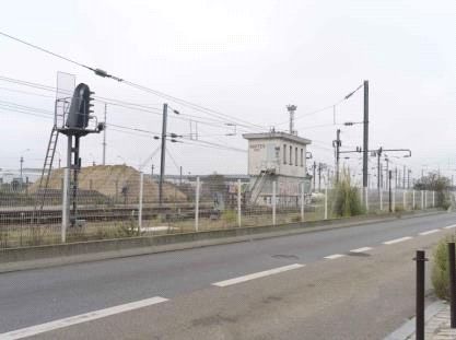
The second area I visited was the Gustave Roch road in the southwest, where the remaining industrial facilities – such as railways and sugar factories – and residential districts coexisted. This area was to the west of the main road connected to the Pont General Audibert, running through the center of the Island of Nantes. The second area I visited was the Gustave Roch road in the southwest, where the remaining industrial facilities – such as railways and sugar factories – and residential districts coexisted. This area was to the west of the main road connected to the Pont General Audibert, running through the center of the Island of Nantes. The opposite side, the east of the Island of Nantes, to the Anatole de Monzie road had a different atmosphere and scenery. The reason was many buildings on that side of the island were old as the outdated industrial facilities. Many old-fashioned brick buildings also insinuated they had been there for a long passage of time. There were some modern buildings in-between, but most of them were facilities built as part of the urban planning. The old-looking of this city seemed to represent Nantes' currently trivial industrial function. Interestingly, I discovered urban landscapes with old buildings made of pretty much new modern materials. It made me think that they seemed to represent the states of urban regeneration.
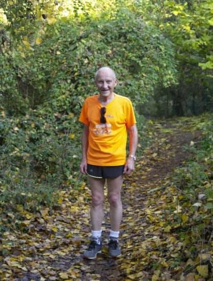
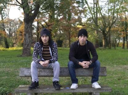
For the third area, I visited Parc de Beaulieu, a green space in the east Nantes. Based on the urban planning in this region, this green space would expand to the south by 2024. The Beaulieu Park was smaller than I had expected. Space was still crowded many locals. The facilities in the park were well maintained than expected, and above all, the park was the only area in Nantes where you could enjoy nature. I tried to talk to various people there. Because most of them were locals, they were not good at English. There was some difficulty communicating with them, but I still had a chance to chat with Hugo and Andrew. Hugo and Andrew were locals who were born in Nantes. They told me about their thoughts on the Nantes urban regeneration from the perspectives of residents. They pointed out the positive side of the project as an increase in income and jobs for residents. After the interview, I decided to go down to the south, the area planned for expansion work by 2024. Looking at the scenery along the road stretching to the south, I recognized that there were points in the city that remained not agreed on the direction of urban planning with residents. The matter of land ownership always follows the issue of urban planning. It is important to note that land on the Island of Nantes is also privately owned property. Inevitably, there must be differences of opinion concerning urban development, and these different views become reflected through the appearance of the city in the end. Unlike the plan, the areas planned for redevelopment into green space by 2024 had well-maintained high-class houses lined up. Looking at them, I wondered whether the city could demolish these buildings and turn this area into green space. The conflict with the residents still seemed to be an unsolved problem. The green project had already been well implemented in place to some extent only in six years. It also seemed to be functioning well in a way.
The last areas I explored were outside the Island of Nantes. They did not look much different from other modern cities. The northern part of the Island of Nantes, where the old town and other institutions were, was very vibrant with a large floating population. These areas had most city functions concentrated, but the examples of diverse uses of old buildings or the green line were only unique things I found. Certainly, Nantes was a tourism city, full of energy.
So far was the journey of my urban exploration. I photographed and documented the city following the geographic trajectory I had envisioned about Nantes based on its urban project. The various occurrences and side effects found under the title of urban regeneration reflect the tangled past, present, and future. At the same time, this reflection throws us the facts that are readable without text. The cities we read in images rather than texts tell us the realities of these cities under the great name of urban planning.
I agree that ten days is such a short time to run a project and derive some outcomes and conclusions. I thought the best thing I could do in Nantes was to become a medium myself and to reflect the current reality of this city employing photo-documenting. In doing so, it will be inappropriate to highlight and deliver only the positive aspects of Nantes. I also tried to look at the dark sides -- contradictions and side effects -- of Nantes to look into different sides of the city and rethink urban regeneration. My conclusion may be that the people and cities of Nantes were not much different from us.
도시와 도큐멘트 : 도시 재생 계획에 따른 낭트 섬의 지리적 궤적을 따라서
박승만
미술원 조형예술과
세계적으로 도시재생의 성공적 모델이라고 일컬어지는 낭트시의 낭트 섬 도시재생 계획은 현재에 이르러 어떤 지점에 놓여있는가? 나는 먼저 도시계획에 따라 구분되는 지역들을 이차적으로 나의 기준으로 재분할(녹지, 개발, 미개발, 구시가지 등)한 뒤 직접 그 지역들을 누비며 도시 재생이 도시환경과 지역민에게 어떠한 영향을 끼치는지 눈으로 확인함과 동시에 짧은 기간이지만 도큐먼트 프로젝트를 진행하였다.낭트 섬의 도시 재생 계획에 따라 섬 전체가 많은 변화를 겪고 있다. 도시재생 전과 현재 그리고 미래로 나아가는 낭트 섬의 모습은 “도시 재생”이라는 큰 계획 아래 현재에 이르러서도 기계가 만들어내는 잡음과 함께 기이한 풍경으로 우리에게 펼쳐진다. 현재까지도 이 변화는 계속해서 변화하고 있다.
I. 연구의 목적 및 중요성
: 낭트 섬 도시재생이 도시에 끼치는 영향이 드러나는 지점들을 도큐먼트 함으로서 현재 도시재생의 실태와 모습들을 되돌아보고자 한다.
II. 연구의 내용 및 범위
: 도시 재생에 따라 변화하는 낭트 섬 일대에 대한 기록 및 주민 인터뷰
III. 연구방법
: 낭트 섬 도시재생 계획에 따라 구분되는 지역을 내 기준으로 재분할한 뒤에 사진 촬영과 인터뷰를 진행
IV. 연구결과
낭트 섬 도시재생에 따라 변화하는 낭트의 모습을 직접 경험할 수 있었고, 그것을 근거할 수 있는 도큐먼트 결과물을 얻을 수 있었다.
나는 낭트의 도시와 그 안에 시민들과의 접촉이 필요했다. 낭트의 도시재생은 어떻게 주민들의 삶에 영향을 끼치고 있으며 그로 인해 그들은 어떻게 살고 있는지 도시의 과거와 현재 그리고 미래는 어떻게 변화하고 있는지 눈으로 확인하고 느끼는 것이 매우 중요했다. 우선 내가 접촉해야 할 구역을 크게 4가지 구역으로 나누었다. 1. 녹지(습지) 구역 (동쪽), 2. 개발 중 / 완료 구역, 3. 개발 예정 구역, 4. 낭트 섬 외부지역(구시가지, 주거지 등), 이렇게 총 4구역으로 나누었고, 가장 처음 접촉한 구역은 낭트 미대와 건축대학이 있는 낭트 섬의 중심에서 서쪽에 치우쳐진 지역이었다. 그곳은 이미 많은 개발이 진행되었거나 진행 중인 상태였는데. 낭트 시가 계획하고 구상한 대로 그 지역에서 끌어내고자 했던 역할을 어느 정도 수행하고 있는 것으로 판단됐다. 그중에 눈에 띄었던 것은 기존 산업 시설(조선, 철강 산업)의 몰락을 상징하는 동시에 몰락한 산업의 잔재물과 예술이 결합하여 재탄생된 낭트를 상징하는 “기계 코끼리”이었다. 낭트 시는 이 테마파크에 힘입어 연 100만 명 이상의 관광객을 유치하고 있다고 발표한 바 있다. 이 지역은 이렇듯 복합적인 기능을 담당하면서 도시의 이곳저곳에 여러 작가의 작품들을 비치해놓았다. 마치 나 자신도 역시 “관광객”이 된듯한 기분이 들었고 도시의 랜드 마크로 상징되는 이 장소에서 낭트 그 자체의 모습보다는 “외부인”에 의해 움직이는 도시의 모습을 발견했다. 타지에서 온 대학생들과 관광객들, 테마파크에서 흘러나오는 웃음소리와 공사장 기계들이 빚어내는 마찰음이 뒤섞이는 이 지역이 주는 괴리감은 내게 꽤 흥미로운 부분이었다. 사람도 건물도 빠르게 움직이고 변화하는 이 지역은 낭트의 다른 지역들과는 확연히 다른 모습들을 관찰할 수 있었다.
두 번째 지역은 철도와 설탕 공장 등 남겨진 산업시설과 거주지 역이 혼합된 남서쪽에 있는 “구스타브 호슈(Gustave Roch)”도로였다. 이 지역은 낭트 섬 중심부를 관통하는 “제네랄 오디베흐 다리(Pont General Audibert)”와 연결된 중앙도로를 기점으로 서쪽에 있는데, 반대편 동쪽에 위치한 “아나톨 드 몽지(Anatole de Monzie)”도로 방향 및 낭트 섬 일대의 다른 지역들과 확연히 다른 분위기와 풍경을 보인다. 그 이유는 낡은 산업시설과 비슷한 시기에 지어졌거나 사용되었을 법한 건물들이 다수 존재하며 꽤 오랜 시간이 흘렀다는 것을 증명하는 벽돌 건물들도 다수 존재하였다. 중간중간 현대 건물들도 보이긴 했지만 대부분 도시 개발 계획의 일환으로 만들어진 시설들이었다. 이 낡은 도시의 모습은 여전히 미미하게라도 남은 낭트 섬 내부의 산업적 기능을 대변해주는 듯했다. 흥미로웠던 점은 오래된 건물들이 현시대에서 사용되는 새로운 재료들을 활용해서 만들어진 듯한 도시풍경들을 발견하였는데 도시 재생의 모습을 대변하는 것 같다는 생각이 들기도 했다.
세 번째 지역은 동쪽에 있는 녹지지역(볼리유 공원 Parc de Beaulieu)이다. 이 녹지지역은 장차 계획에 따라 2024년까지 남쪽까지 확장할 예정이다. 볼리유 공원은 생각보다 소규모 공원이었으나, 많은 지역주민이 이용하는 공간이기도 했다. 생각보다 잘 정비되어 있었고 낭트 섬 안에서 유일하게 자연을 맛볼 수 있는 지역이기도 하다. 그곳에서 다양한 사람들과의 접촉을 시도하였는데, 대부분 낭트에서 거주하는 지역주민들이었다. 대부분 영어를 잘하지 못해 의사소통에 어려움을 겪었으나 낭트에서 태어나서 현재까지 거주하고 있는 ‘휴고’와 ‘앤드루’를 만날 수 있었다. 그들에게서 나는 낭트의 도시재생 개발에 대해 지역주민으로서 여러 가지 생각을 들을 수 있었다. 대표적인 이야기는 긍정적인 측면에 대해서 이야기하였는데, 지역주민들에게 있어 소득과 일자리의 증가를 가져왔다는 내용과 비슷한 내용이었다. 인터뷰를 끝내고 나는 2024년까지 확장하고자 계획되어 있는 남쪽으로 내려가 보기로 하였다. 도로를 따라 마주한 풍경들을 보고 느낀 점은 여전히 지역주민들과 합의되지 않은 지점들이 도시 안에서 발견된다는 점이었다. 도시재생에 앞서 낭트 섬의 토지는 각자 개인에게도 소유권이 존재한다. 그러므로 해당 지역 개발을 진행하는 데 있어 발생하는 의견 차이가 분명히 존재하고 그러한 요소들이 도시의 모습을 통해 드러난다는 것이다. 2024년까지 녹지로 개발하기로 계획된 구역들은 계획과는 달리 매우 잘 정비된 고급주택들이 늘어서 있었다. 그것을 보고든 내 생각은 “과연 저런 건물들을 허물고 이 지역을 녹지화할 수 있을 것인가?"이었다. 아직 주민들과의 갈등을 끝나지 않은 듯했다. 불과 6년 안에 녹지화 계획이 이미 어느 정도 자리 잡았으며 또한 어느 정도 그 기능을 원활히 수행하고 있어 보였다.
마지막으로 살펴본 낭트 섬 외부 지역들은 현대 여타 다른 도시와 다를 바 없는 모습을 보였다. 구시가지와 기타 기관들이 위치한 낭트 섬 북쪽 지역은 굉장히 활발하고 유동인구가 많았다. 도시의 기능이 집중된 곳이었으나 다만 특색이 있었던 것은 남겨진 건축물들의 다채로운 활용이나 “그린라인” 같은 것들이었다. 확실히 낭트는 관광도시의 모습을 갖추고 있었으며 또한 활기찬 모습을 보인다.
나는 이렇듯 낭트시의 도시 재생 계획 즉 내가 구상한 지리적 궤적을 따라 일종의 사진 탐사 및 도큐먼트 프로젝트를 진행했다. 도시재생이라는 명목 아래 발생하는 갖가지 요소들과 부작용 등 도시가 변화하면서 흩날리는 일종의 일면들은 뒤엉킨 과거, 현재, 미래를 반영함과 동시에 일종의 “글은 없지만 읽히는 사실"을 우리에게 던진다. 텍스트가 아닌 이미지로 읽히는 도시의 모습들은 "도시재생"이라는 거대한 명목 아래 이루어지는 이 도시의 현실을 반추하도록 작용한다.
10일이라는 짧은 프로젝트를 통해 어떠한 결과와 결론을 도출한다는 것은 사실 무리가 있음에 동의하며, 나는 내가 다루고 있는 사진이라는 매체가 가지고 있는 일차적 속성에 따라 현재 낭트라는 도시의 현실을 나라는 매개체가 반영하고 또 반추하도록 하는 것이 내가 이 도시에서 할 수 있는 최선이라 생각했다. 이 도시의 긍정적인 면만을 부각하고 관철하는 것이 우리의 역할은 아닐 것이다. 도시가 가진 모순과 부작용 즉 어두운 부분들, 그로 인해 발생하는 도시의 다양한 모습들을 통해 또한 다시 “도시재생”이란 무엇인지 생각해보게 되는 프로젝트였다.
어쩌면 우리네 모습과도 꽤 닮아있는 그들의 모습을 발견했다는 것이 결론이라면 결론이라고 이야기할 수 있을 것 같다.