Study of Historicity and Placeness of the city of Nantes, France – Based on Historical and Cultural Traces of the Island of Nantes and Current State of Their Uses in Urban Regeneration Project –
Jo Do-hee
Department of Architecture (graduate program)
Historically, Nantes faces an economic crisis with the decline of the shipbuilding industry that used to be its flagship industry in the 1960s. With the replacement of the government of enforcement in 1989, Nantes finally commences its urban regeneration project. Today, Nantes has acquired titles of the “most desirable place in Europe,” “innovative city,” “green city,” etc.
Nantes’ urban planning sets its goal to preserve and reform historical traces and memories of the old city center – those of shipyard facilities. The project has focused on this goal since the beginning of implementation till now. As a consequence, Nantes is known for undergoing a successful urban regeneration today.
This research analyzes how Nantes has specifically carried out its urban regeneration project based on its goal. It also examines the historicity and spatiality of the Island of Nantes. This paper will further suggest new directions and possibilities for sustainable urban regeneration for the future of Nantes.
I. Objective
“ON AVANCE TOUJOURS EN REGARDANT ARRIERE.”
(WE ALWAYS MOVE FORWARD, LOOKING BACK.)
– WALTER BENJAMIN –
: AS WALTER BENJAMIN SAID, WE MOVE FORWARD TO THE FUTURE BY LOOKING BACK AT OUR PAST VESTIGES.
Historically, Nantes faces an economic crisis with the decline of the shipbuilding industry that used to be its flagship industry in the 1960s. With the replacement of the government of enforcement in 1989, Nantes finally commences its urban regeneration project. Today, Nantes has acquired titles of the “most desirable place in Europe,” “innovative city,” “green city,” etc.
Nantes’ urban planning sets its goal to preserve and reform historical traces and memories of the old city center – those of shipyard facilities. The project has focused on this goal since the beginning of implementation till now. As a consequence, Nantes is known for undergoing a successful urban regeneration today.
This research analyzes how Nantes has specifically carried out its urban regeneration project based on its goal. It also examines the historicity and spatiality of the Island of Nantes. This paper will further suggest new directions and possibilities for sustainable urban regeneration for the future of Nantes.
ON AVANCE TOUJOURS EN REGARDANT ARRIERE.
II. Extent of the Research
The research extent is limited to the regions of the old town and the Island of Nantes.
As the government of enforcement changed in 1989, Nantes launched SAMOA (or Western Atlantic Housing Society ), a local public enterprise, and started working on urban regeneration. The process gained momentum since then.
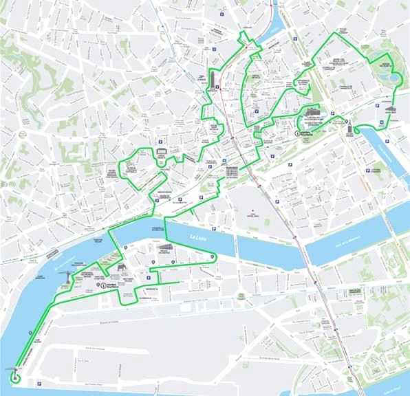
For project Nantes, SAMOA set to preserve historical places of the city – the city’s industrial heritage – and expand green spaces. Before the beginning of the project, the Island of Nantes was full of remnants of the past – like abandoned shipyard facilities and closed factories. Hence the project has concentrated on transforming modern heritage into cultural and tourism content. At the same time, it also pursued integrating high-tech ventures, educational and living facilities around Nantes to develop it into a new city. The urban planning project for the Island of Nantes began in 2000 and will last until 2024.
I will investigate how and why SAMOA planned some projects – such as the green line or Square Jacques de Bollardiere – concerning spatiality. I will also compare the blueprints of these projects with their actual statuses now. Based on the comparison, I will classify the investigated areas into ones that successfully followed original plans and those that failed to do so. I will also look for spaces in Nantes that have the potential for development.
III. Research Methods
This research analyzes Nantes’ urban regeneration project that considers its historical traces according to the following criteria: (1) historical and physical records of the city (e. g. maps of old Nantes, or aerial photograph of the old town), (2) ongoing projects and plans by SAMOA that leads the Nantes project, (3) my observations and experiences in Nantes. Then it will identify the significance of the Nantes project and the limitations it confronts at this point.
IV. Results
1. I derived a new map of the regions on the Island of Nantes.
– Through this mapping process, I marked the spots with spatial significance and considered the areas that seem available for re-development in the future.
2. Connection to Self-exploration
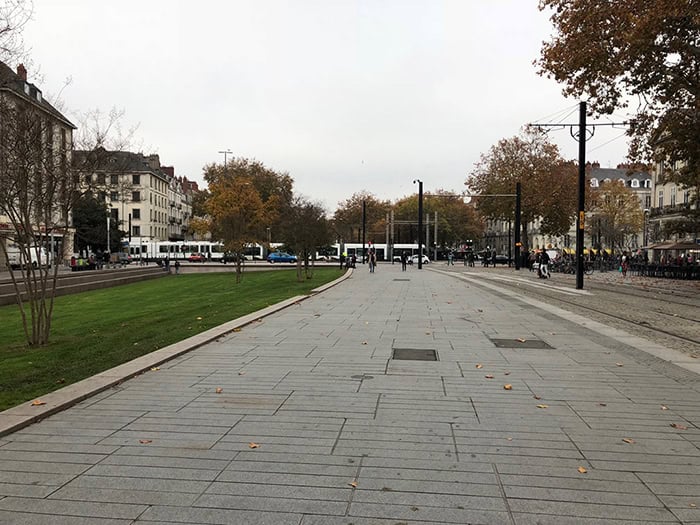
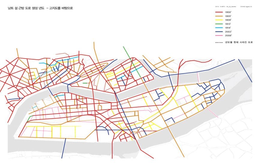
– Supposedly, the Nantes project is based on historical values and spatiality of Nantes. Nonetheless, I sensed disparity between the old town and the Island of Nantes in reality. The old parts of Nantes that genuinely embraced the historical traces were quite different from the Island of Nantes, which was said to preserve historical memories. My impression became stronger as I was walking along the green line. In the old town, most routes that run between buildings consider spatial sequences and experiences. In contrast, the paths on the Island of Nantes merely seemed to connect a project to another project. [Image 1] The spaces to experience the island were not sufficient. It might be only because the urban regeneration project was incomplete now, but there were many differences between the areas on the island and the space divisions SAMOA was planning.
Is there any way to connect the main road running through the Island of Nantes to residential areas? The contexts surrounding the main road linked to the old city center, which has existed from 1500 years ago, have undergone utter changes that it was difficult to find any past traces.
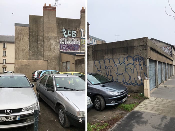
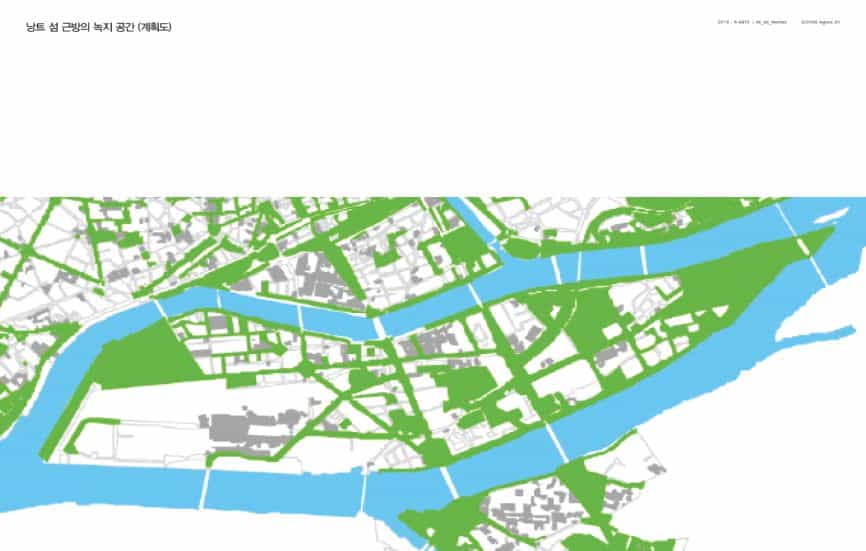
Despite it all, there are still past remnants, residential places, and railways used by industrial workers in the past on the side streets. The number of visitors decreased with deterioration, yet the remnants still maintained their original structures as factory facilities. Unlike the number of green spaces planned by SAMOA as in [Image 4], the far end of the island rarely had any open green spaces.
People will have more enriched spatial experiences in the old city center and the Island of Nantes if the newly derived spaces and the green line with additional proposed base spaces are combined.
프랑스 낭트(NANTES) 시의 역사성과 장소성에 관한 연구 – 낭트 섬(ILE DE NANTES) 내 역사 문화 흔적과 도시 재생 사업을 통한 활용 현황 분석을 바탕으로
조도희
미술원 건축(전문사)
역사적으로 프랑스의 도시 낭트는 1960년대 주력 산업이었던 조선업의 쇠퇴로 경제 위기를 맞이한다. 1989년 시행 정부의 교체로 낭트 시는 대대적인 도시재생 사업을 진행하게 된다. 오늘날 낭트 시는 국제적으로도 “유럽에서 가장 살기 좋은 도시”, “혁신도시“, 녹색도시“등의 타이틀을 거머쥐게 된다. 낭트시의 도시재생 사업의 가장 큰 방향성은 ‘기존 도시가 가진 과거의 기억과 역사의 흔적들, 특히 낭트 섬의 조선업 시설들에 대한 보존과 재정비’이다. 이를 중심축으로 추진되기 시작하여 현재까지도 진행되고 있으며, 성공적인 도시재생이라는 평을 듣고 있다. 본 연구는 낭트시가 추구하는 도시재생 사업이 실제로 “과거의 기억과 역사적 흔적들을 어떤 방식으로 고려하고 반영했는지”에 대한 분석을 진행하며, 향후 진행될 낭트 섬의 지속적인 도시재생에 있어 필요한 낭트 섬의 장소성과 역사성을 파악하여 방향성과 가능성에 대한 제안을 해보고자 한다.
I. 연구의 목적 및 중요성
ON AVANCE TOUJOURS EN REGARDANT ARRIERE.
우리는 앞으로 나아갈 수 있다. 뒤를 돌아보면서
– 발터 벤야민
: 발터 벤야민의 말처럼 우리는 과거의 역사의 흔적을 돌아보면서 미래를 향한 새로운 발돋움을 할 수 있다.
역사적으로 프랑스의 도시 낭트는 1960년대 주력 산업이었던 조선업의 쇠퇴로 경제 위기를 맞이한다. 1989년 시행정부의 교체로 낭트 시는 대대적인 도시재생 사업을 진행하게 된다. 오늘날 낭트 시는 국제적으로도 “유럽에서 가장 살기 좋은 도시”, “혁신도시”, “녹색도시” 등 타이틀을 거머쥘 수 있게 되었다.
낭트 시의 도시재생 사업의 가장 큰 방향성은 ‘기존 도시가 갖고 있는 과거의 기억과 역사의 흔적들, 특히 낭트 섬의 조선업 시설들에 대한 보존과 재정비’이다. 이를 중심축으로 추진되기 시작하여 현재까지도 진행되고 있으며, 성공적인 도시재생이라는 평을 듣고 있다.
이에 본 연구는 낭트 시가 추구하는 도시재생 사업이 실제로 “과거의 기억과 역사적 흔적들을 어떤 방식으로 고려하고 반영했는지”에 대한 분석을 진행하며, 향후 진행될 낭트 섬의 지속적인 도시재생에 있어 필요한 일 드 낭트의 장소성과 역사성을 파악하여 방향성과 가능성에 대해 제안해보고자 한다.
II. 연구의 내용 및 범위
낭트의 구도심 영역과 일 드 낭트(낭트 섬) 영역으로 한정.
89년 시행 정부의 교체와 더불어 ‘일 드 낭트’의 지방공기업 ‘사모아(SAMOA·서대서양도시권 정비회사)’가 출범하면서 ‘일 드 낭트’ 지역의 도시재생은 본격화되었다. 도시재생사업은 더욱 탄력받았다. 사모아는 과거의 흔적인 조선업 시설들과 폐공장이 가득한 낭트 섬의 프로젝트의 방향을 ‘도시산업유산, 즉 역사적 공간의 보존’과 ‘녹색 공간 확대’로 잡았다. 프로젝트의 큰 과제로써 근대유산을 문화·관광 콘텐츠로 재활용하는 동시에 첨단기업, 교육, 생활 시설을 이 일대로 집적화해 신도시로 만드는 ‘일 드 낭트’ 프로젝트는 2000년 시작돼 2024년까지 계속 진행되고 있다. 사모아에서 진행하는 많은 프로젝트(ex:그린라인, 광장) 등이 어떤 의도로 어떻게 계획되었는지에 대해 공간적으로 파악하고, 계획도면과 실제 현황을 비교 분석한다. 계획에 맞는 성과를 얻는 공간과 그렇지 못한 공간들을 분류하고, 새롭게 향후 개발 가능한 ‘낭트 섬의 장소성을 갖는 공간’ 들을 찾아본다.
III. 연구 방법
낭트시의 ⓵고지도와 과거 항공사진 등 역사적인 물리적 기록, ⓶도시재생 사업을 진행하는 SAMOA의 진행 프로젝트 및 미래 계획, ⓷방문하여 직접 보고 경험한 요소를 바탕으로 낭트시에서 진행하고 있는 ‘역사적 흔적을 고려한 도시재생 사업’을 분석한다. 이에 이어 낭트 섬의 도시재생 사업의 의의와 현재 시점의 한계를 파악한다.
IV. 연구결과
1. 낭트 섬 영역의 새로운 유형의 지도와 같은 결과물이 도출된다.
: 지도에 매핑하는 방식을 통해 낭트의 주요 장소성의 지점들을 표현하고 앞으로 개발 가능할 것으로 보이는 지점들에 대해 고려할 수 있다.
2. 개인답사와 연결
: ‘일 드 낭트 프로젝트는 낭트의 역사적 가치와 장소성을 기반으로 한 프로젝트였음에도 불구하고, 실제 구도심과 낭트섬과의 괴리감을 느낄 수 있었다. 과거의 흔적이 그대로 드러나는 구도심과 흔적을 유지한다고 ‘말’하는 낭트 섬에서의 간극이 존재했는데, 이런 생각은 그린라인을 따라 걸어가면서 더 확신을 하게 되었다. 구도심에서는 건물의 사이로 걸어가는 듯 공간적 시퀀스와 공간적 경험들을 고려한 동선이 주를 이루었다면 낭트 섬에서는 프로젝트와 프로젝트 사이를 단지 연결해놓은 듯한 느낌이 들었다. [그림1] 걸어가면서 경험할 공간들이 상대적으로 낭트 섬 안에는 부족했다. 아직 도시재생 프로젝트가 진행 중이었기 때문일지도 모르지만, 현재로서는 섬 안의 공간들이 사모아에서 진행·계획하는 공간 구획 영역과도 많은 차이가 존재했다.
낭트 섬의 중심 도로 공간과 주거 지역들과 연결을 할 수 있는 방법은 없을까? 1500여 년부터 존재하던 구도심과 연결되는 길의 주변 컨텍스트들은 현재 과거의 흔적을 찾아보기엔 어려울 정도로 새로운 형태들로 변화되어 있었다.
그러나 그 이면도로에 있는 공간들에서 과거의 흔적들과 과거 산업 공간에서 근무하던 사람들의 주거공간으로 보이는 장소, 과거 물자들을 옮기던 철로들이 아직 존재하고 있다. 낙후됨으로 인해 현재 사람들의 발길은 줄었지만, 그 형태가 공장시설들의 골조들만큼이나 그 원 형태로 남아있는 것을 확인할 수 있었다. 섬의 극동 쪽 부분의 녹지 공간은 사모아에서 계획하는 녹지공간 [그림4] 만큼에는 거의 못 미치는, 현재 낭트 섬에는 오픈 녹지공간이 거의 없다고 할 수 있다.
새롭게 도출해 낸 공간들이 현재 상용되는 ‘그린라인’에 새롭게 제안하는 거점 공간들을 접목한다면 구도심과 낭트 섬의 공간 경험을 더 풍부하게 할 수 있을 것이다.